IMAGES TAKEN NEAR TO
Briar Gardens, PETERHEAD, AB42 5FH
Introduction
This page details the photographs taken nearby to Briar Gardens, AB42 5FH by members of the Geograph project.
The Geograph project started in 2005 with the aim of publishing, organising and preserving representative images for every square kilometre of Great Britain, Ireland and the Isle of Man.

There are currently over 7.5m images from over14,400 individuals and you can help contribute to the project by visiting https://www.geograph.org.uk
Image Map
Images are licensed for reuse under creativecommons.org/licenses/by-sa/2.0
Notes
- Clicking on the map will re-center to the selected point.
- The higher the marker number, the further away the image location is from the centre of the postcode.
Image Listing (5 Images Found)
Images are licensed for reuse under creativecommons.org/licenses/by-sa/2.0
Image
Details
Distance
1
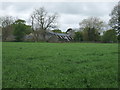
Modular Housing at Mintlaw
1980s Housing Estates made up of modular units - 4 sections trucked up from the factory and a roof added on.
Image: © Ken Fitlike
Taken: 12 May 2007
0.11 miles
2
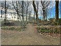
The Limbo Trail
Trees down on the Nether Aden Path which makes for an interesting walk.
Image: © Ralph Greig
Taken: 13 Jan 2022
0.15 miles
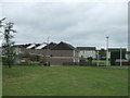
3
Nether Aden Road, Mintlaw
Towards Old Dear.
Image: © JThomas
Taken: 22 Aug 2020
0.20 miles
4
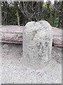
Old Milestone by the A950, Station Road, Longside parish
Aberdeen granite by the A950, in parish of Longside (Aberdeen District), West of A952 roundabout Mintlaw, outside Hanewith on pavement, South side of road.
Inscription reads:-
9
(To Peterhead)
Surveyed
Milestone Society National ID: AD_PHNP09
Image: © Milestone Society
Taken: Unknown
0.22 miles