IMAGES TAKEN NEAR TO
Clola, PETERHEAD, AB42 5DA
Introduction
This page details the photographs taken nearby to AB42 5DA by members of the Geograph project.
The Geograph project started in 2005 with the aim of publishing, organising and preserving representative images for every square kilometre of Great Britain, Ireland and the Isle of Man.

There are currently over 7.5m images from over14,400 individuals and you can help contribute to the project by visiting https://www.geograph.org.uk
Image Map
Images are licensed for reuse under creativecommons.org/licenses/by-sa/2.0
Notes
- Clicking on the map will re-center to the selected point.
- The higher the marker number, the further away the image location is from the centre of the postcode.
Image Listing (4 Images Found)
Images are licensed for reuse under creativecommons.org/licenses/by-sa/2.0
Image
Details
Distance
1
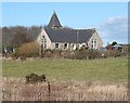
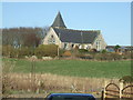
Clola Kirk
This is the former Free Kirk at Clola, no longer used for worship. Its unusual design by Campbell, Douglas and Stevenson dates from 1863. The 1976 map, curiously, shows it as a kirk with a (round) tower rather than a (square) spire. An 'Original Seceder' congregation was formed here in 1769 and a kirk built in 1784, and this kirk may or may not be the replacement for the earlier one. It is in the parish of Old Deer.
Image: © Anne Burgess
Taken: 17 Mar 2010
0.19 miles
3
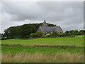
Church Croft, Clola
Clola is a scattered community mid-way on the Ellon to Mintlaw road. Several interesting buildings in the area of which this is the most prominent
Image: © Ken Fitlike
Taken: 6 Mar 2007
0.21 miles