IMAGES TAKEN NEAR TO
Ardallie, PETERHEAD, AB42 5BQ
Introduction
This page details the photographs taken nearby to AB42 5BQ by members of the Geograph project.
The Geograph project started in 2005 with the aim of publishing, organising and preserving representative images for every square kilometre of Great Britain, Ireland and the Isle of Man.

There are currently over 7.5m images from over14,400 individuals and you can help contribute to the project by visiting https://www.geograph.org.uk
Image Map
Images are licensed for reuse under creativecommons.org/licenses/by-sa/2.0
Notes
- Clicking on the map will re-center to the selected point.
- The higher the marker number, the further away the image location is from the centre of the postcode.
Image Listing (6 Images Found)
Images are licensed for reuse under creativecommons.org/licenses/by-sa/2.0
Image
Details
Distance
1

Ardallie Kirk
Ardallie Kirk was built as a chapel of ease for the congregation of the quoad sacra parish of Ardallie, part of the parish of Old Deer. Designed by William Clarke in 1857, it is a category 'B' listed building, but is no longer in use as a kirk. Next door to it is the manse, also designed by William Clarke, in 1859. It too is listed as part of the group including the kirk. The first minister of Ardallie, appointed in 1858 to its predecessor mission, was William Burgess (no relation to me!), born in Rathven in Banffshire in 1829. He took up the post in 1862 and remained in the charge until his death in 1889. Coincidentally, Peter Mitchell's Diary in the Press and Journal of 1 May 2009 reports that the present occupants of the Manse discovered in a loft letters written in the 1930s to the Diarist's uncle, the son of Charles Macdonald, a later incumbent of Ardallie. The full story is at http://www.pressandjournal.co.uk/Article.aspx/1190485
Image: © Anne Burgess
Taken: 17 Mar 2010
0.09 miles
2
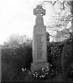
Ardallie war memorial
A poor quality photograph, but the names of the fallen are visible. There is no Canmore record.
Image: © Bill Harrison
Taken: 16 Apr 2021
0.09 miles
3
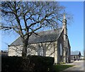
Ardallie Parish Kirk
Built 1857 on a north-south orientation and B-listed (LB16057: http://portal.historicenvironment.scot/designation/LB16057 ) but now out of use.
Image: © Bill Harrison
Taken: 16 Apr 2021
0.10 miles
4
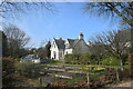
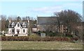
Former manse, Ardallie
Built 1859 alongside the church and C-listed (LB16058: http://portal.historicenvironment.scot/designation/LB16058 ).
Image: © Bill Harrison
Taken: 16 Apr 2021
0.10 miles
5
Ardallie Kirk
Ardallie Kirk was built as a chapel of ease for the congregation of the quoad sacra parish of Ardallie, part of the parish of Old Deer. Designed by William Clarke in 1857, it is a category 'B' listed building, but is no longer in use as a kirk. Next door to it is the manse, also designed by William Clarke, in 1859. It too is listed as part of the group including the kirk. The first minister of Ardallie, appointed in 1858 to its predecessor mission, was William Burgess (no relation to me!), born in Rathven in Banffshire in 1829. He took up the post in 1862 and remained in the charge until his death in 1889. Coincidentally, Peter Mitchell's Diary in the Press and Journal of 1 May 2009 reports that the present occupants of the Manse discovered in a loft letters written in the 1930s to the Diarist's uncle, the son of Charles Macdonald, a later incumbent of Ardallie. The full story is at http://www.pressandjournal.co.uk/Article.aspx/1190485
Image: © Anne Burgess
Taken: 17 Mar 2010
0.11 miles