IMAGES TAKEN NEAR TO
Mintlaw, PETERHEAD, AB42 5BA
Introduction
This page details the photographs taken nearby to AB42 5BA by members of the Geograph project.
The Geograph project started in 2005 with the aim of publishing, organising and preserving representative images for every square kilometre of Great Britain, Ireland and the Isle of Man.

There are currently over 7.5m images from over14,400 individuals and you can help contribute to the project by visiting https://www.geograph.org.uk
Image Map
Images are licensed for reuse under creativecommons.org/licenses/by-sa/2.0
Notes
- Clicking on the map will re-center to the selected point.
- The higher the marker number, the further away the image location is from the centre of the postcode.
Image Listing (3 Images Found)
Images are licensed for reuse under creativecommons.org/licenses/by-sa/2.0
Image
Details
Distance
1
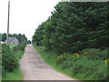
Road to Backhill of Lenabo
Along western edge of Lenabo Forest
Image: © Ken Fitlike
Taken: 12 Jun 2007
0.03 miles
2
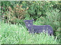
Wooden wildcat , Lenabo Forest
...possibly a warning to keep your wee doggy on a lead!
Image: © Ken Fitlike
Taken: 12 Jun 2007
0.20 miles
3
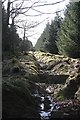
Forest Drain
This seems to have been dug, or possibly re-dug, relatively recently.
Image: © Anne Burgess
Taken: 17 Mar 2010
0.23 miles