IMAGES TAKEN NEAR TO
Mintlaw, PETERHEAD, AB42 5AY
Introduction
This page details the photographs taken nearby to AB42 5AY by members of the Geograph project.
The Geograph project started in 2005 with the aim of publishing, organising and preserving representative images for every square kilometre of Great Britain, Ireland and the Isle of Man.

There are currently over 7.5m images from over14,400 individuals and you can help contribute to the project by visiting https://www.geograph.org.uk
Image Map
Images are licensed for reuse under creativecommons.org/licenses/by-sa/2.0
Notes
- Clicking on the map will re-center to the selected point.
- The higher the marker number, the further away the image location is from the centre of the postcode.
Image Listing (6 Images Found)
Images are licensed for reuse under creativecommons.org/licenses/by-sa/2.0
Image
Details
Distance
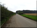
2
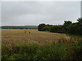
Cereal crop beside gas distribution station
Image: © JThomas
Taken: 23 Aug 2020
0.17 miles
4
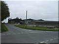
Newton Farm
The closest sheds are a piggery unit. Be grateful that digital cameras don't capture the pungent aroma!
Image: © Ken Fitlike
Taken: 4 May 2007
0.19 miles
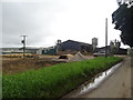
6
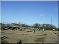
Gas Metering Station at Kinknockie
on the pipeline from St Fergus North Sea Gas Terminal to National distribution grid
Image: © Ken Fitlike
Taken: 6 Mar 2007
0.23 miles