IMAGES TAKEN NEAR TO
Ardallie, PETERHEAD, AB42 5AN
Introduction
This page details the photographs taken nearby to AB42 5AN by members of the Geograph project.
The Geograph project started in 2005 with the aim of publishing, organising and preserving representative images for every square kilometre of Great Britain, Ireland and the Isle of Man.

There are currently over 7.5m images from over14,400 individuals and you can help contribute to the project by visiting https://www.geograph.org.uk
Image Map
Images are licensed for reuse under creativecommons.org/licenses/by-sa/2.0
Notes
- Clicking on the map will re-center to the selected point.
- The higher the marker number, the further away the image location is from the centre of the postcode.
Image Listing (7 Images Found)
Images are licensed for reuse under creativecommons.org/licenses/by-sa/2.0
Image
Details
Distance
2
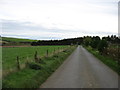
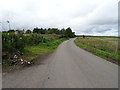
Minor road heading for Ardallie
This road meets the A952 just after the trees ahead.
Image: © David Purchase
Taken: 1 Oct 2014
0.08 miles