IMAGES TAKEN NEAR TO
Longside, PETERHEAD, AB42 4XT
Introduction
This page details the photographs taken nearby to AB42 4XT by members of the Geograph project.
The Geograph project started in 2005 with the aim of publishing, organising and preserving representative images for every square kilometre of Great Britain, Ireland and the Isle of Man.

There are currently over 7.5m images from over14,400 individuals and you can help contribute to the project by visiting https://www.geograph.org.uk
Image Map
Images are licensed for reuse under creativecommons.org/licenses/by-sa/2.0
Notes
- Clicking on the map will re-center to the selected point.
- The higher the marker number, the further away the image location is from the centre of the postcode.
Image Listing (11 Images Found)
Images are licensed for reuse under creativecommons.org/licenses/by-sa/2.0
Image
Details
Distance
5
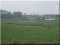
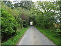
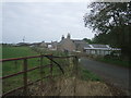
Murky morning at Monyruy
big steading plus cottages and sheep..this farm possesses a very impressive 'big hoose'
Image: © Ken Fitlike
Taken: 17 Oct 2006
0.05 miles
6
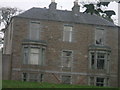
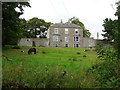
Monyruy 'Big Hoose'
a very handsome farm estate house
Image: © Ken Fitlike
Taken: 17 Oct 2006
0.05 miles
7
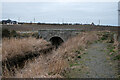
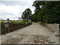
Buthlaw Bridge
Part of this popular path and at the car parking area
Image: © Ralph Greig
Taken: 27 Feb 2023
0.13 miles
8
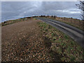
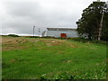
Car park for the Buthlaw Field path
At this location there is space for 5 cars and is the official car park for the field path
Image: © Ralph Greig
Taken: 20 Jan 2022
0.15 miles
10
cottages at Flushing, near Longside
just off the A950 Peterhead to Longside road....
Image: © Ken Fitlike
Taken: 15 Oct 2006
0.22 miles