IMAGES TAKEN NEAR TO
Rora, PETERHEAD, AB42 4UP
Introduction
This page details the photographs taken nearby to AB42 4UP by members of the Geograph project.
The Geograph project started in 2005 with the aim of publishing, organising and preserving representative images for every square kilometre of Great Britain, Ireland and the Isle of Man.

There are currently over 7.5m images from over14,400 individuals and you can help contribute to the project by visiting https://www.geograph.org.uk
Image Map
Images are licensed for reuse under creativecommons.org/licenses/by-sa/2.0
Notes
- Clicking on the map will re-center to the selected point.
- The higher the marker number, the further away the image location is from the centre of the postcode.
Image Listing (4 Images Found)
Images are licensed for reuse under creativecommons.org/licenses/by-sa/2.0
Image
Details
Distance
2
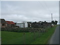
Cuttyhill Croft
note old railway carriages used as shed units. After the Beeching rail cut backs in the 60s railway carriages became a ubiquitous feature of smaller farms. Not many have survived as long as these
Image: © Ken Fitlike
Taken: 15 Sep 2006
0.06 miles