IMAGES TAKEN NEAR TO
Inn Brae, PETERHEAD, AB42 4TP
Introduction
This page details the photographs taken nearby to Inn Brae, AB42 4TP by members of the Geograph project.
The Geograph project started in 2005 with the aim of publishing, organising and preserving representative images for every square kilometre of Great Britain, Ireland and the Isle of Man.

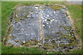
There are currently over 7.5m images from over14,400 individuals and you can help contribute to the project by visiting https://www.geograph.org.uk
Image Map
Images are licensed for reuse under creativecommons.org/licenses/by-sa/2.0
Notes
- Clicking on the map will re-center to the selected point.
- The higher the marker number, the further away the image location is from the centre of the postcode.
Image Listing (42 Images Found)
Images are licensed for reuse under creativecommons.org/licenses/by-sa/2.0
Image
Details
Distance
1
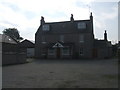
Bruce Arms Hotel, Longside
currently closed. pile of rubble at right of building is the old 'lean-to' Public Bar. Never luxurious. Village trade lost to prosperous Football Social Club and Golf Club.
Image: © Ken Fitlike
Taken: 17 Sep 2006
0.01 miles
2
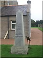
Jamie Fleeman's grave, Longside
http://www.classic-literature.co.uk/bram-stoker/draculas-guest/ebook-page-66.asp
Image: © Ken Fitlike
Taken: 17 Oct 2006
0.01 miles
3
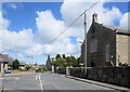
Junction of Inn Brae and Inverquhomery Road, Longside...
...with the parish kirk to the right. Inverquhomery means 'infall of the burn formed by the union of two other burns' according to Celtic Place-names in Aberdeenshire by John Milne.
Image: © Bill Harrison
Taken: 22 May 2021
0.02 miles
4
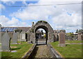
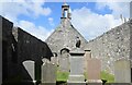
Entrance arch, Longside kirkyard
Dated 1705 but possibly erected with the church in 1620. A-listed (LB9412;
http://portal.historicenvironment.scot/designation/LB9412 ) for its rarity; compare a similar arch at Chapel of Garioch, some 40 km to the southwest: https://www.geograph.org.uk/photo/4647329 .
Image: © Bill Harrison
Taken: 22 May 2021
0.02 miles
5
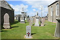
18th Century grave-slabs, Longside kirkyard
The left-hand slab commemorates John Robertson (d. 1719), his wife Elspeth (d. 1727) and other family members. Note the full complement of memento mori symbols: mort-head (skull) and crossbones, 'deid bell', sexton's tools and hourglass. The right-hand slab is too eroded to make out.
Image: © Bill Harrison
Taken: 22 May 2021
0.02 miles
6
Longside old kirk (interior view)
Like many ruined Scottish kirks, the interior space was later used for burials.
Image: © Bill Harrison
Taken: 22 May 2021
0.02 miles
7
War grave, Longside kirkyard
Andrew Kilgour, who apparently died at Longside aged 17 or 18 and a separate grave to the Longside war memorial.
Image: © Bill Harrison
Taken: 22 May 2021
0.03 miles
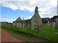
8
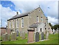
Longside parish kirk
Built 1836 to replace the 1620 kirk just to the south and designed by John Smith. B-listed (LB9411): http://portal.historicenvironment.scot/designation/LB9411 .
Image: © Bill Harrison
Taken: 22 May 2021
0.03 miles
9
Longside kirkyard and old kirk
Old kirk dates from 1620 and was replaced by a new church in 1836 - Image
Image: © JThomas
Taken: 24 Aug 2020
0.03 miles
10
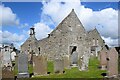
Longside old kirk
The kirk with its fine Renaissance bellcote displaying the Sibbald and Bruce arms was built in 1620 when the new parish of Longside was hived-off from Peter-Ugie (now Peterhead). Its disjunction with Peterhead was confirmed by an act of Parliament of 1637: "erectit in ane severall paroch kirk be it selff, and disunited fra the said mother kirk of Peterugie". A-listed (LB9410): http://portal.historicenvironment.scot/designation/LB9410 as a fine example of a post-Reformation rectangular kirk.
Image: © Bill Harrison
Taken: 22 May 2021
0.03 miles