IMAGES TAKEN NEAR TO
Springfield Gardens, PETERHEAD, AB42 4QZ
Introduction
This page details the photographs taken nearby to Springfield Gardens, AB42 4QZ by members of the Geograph project.
The Geograph project started in 2005 with the aim of publishing, organising and preserving representative images for every square kilometre of Great Britain, Ireland and the Isle of Man.

There are currently over 7.5m images from over14,400 individuals and you can help contribute to the project by visiting https://www.geograph.org.uk
Image Map
Images are licensed for reuse under creativecommons.org/licenses/by-sa/2.0
Notes
- Clicking on the map will re-center to the selected point.
- The higher the marker number, the further away the image location is from the centre of the postcode.
Image Listing (8 Images Found)
Images are licensed for reuse under creativecommons.org/licenses/by-sa/2.0
Image
Details
Distance
1
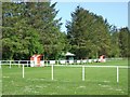
Maud Leisure Park
Home of Maud Juniors FC
Image: © Ken Fitlike
Taken: 10 May 2007
0.10 miles
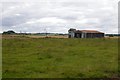
5
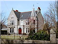
Villa
A fine Scottish baronial style villa with all the trimmings (corner tower, crow-step gable end...) and leaving no doubt as to its building date of 1905.
Image: © Bill Harrison
Taken: 2 Apr 2016
0.21 miles
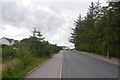
7
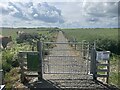
Maud's Windmill walk
A 6km walk in farmland round the Village of Maud
Image: © Ralph Greig
Taken: 21 Jun 2023
0.22 miles
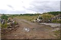
8
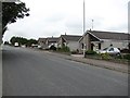
Castle Road, Maud
The Castle referred to is Fedderate Castle Image
Image: © Oliver Dixon
Taken: 22 May 2008
0.23 miles