IMAGES TAKEN NEAR TO
St. Fergus, PETERHEAD, AB42 4NT
Introduction
This page details the photographs taken nearby to AB42 4NT by members of the Geograph project.
The Geograph project started in 2005 with the aim of publishing, organising and preserving representative images for every square kilometre of Great Britain, Ireland and the Isle of Man.

There are currently over 7.5m images from over14,400 individuals and you can help contribute to the project by visiting https://www.geograph.org.uk
Image Map
Images are licensed for reuse under creativecommons.org/licenses/by-sa/2.0
Notes
- Clicking on the map will re-center to the selected point.
- The higher the marker number, the further away the image location is from the centre of the postcode.
Image Listing (5 Images Found)
Images are licensed for reuse under creativecommons.org/licenses/by-sa/2.0
Image
Details
Distance
1
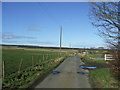
view towards Outhill Cottage
....and beyond to St Fergus Moss ( the 'black earth' streak across mid-frame)
Image: © Ken Fitlike
Taken: 2 Mar 2007
0.16 miles
2
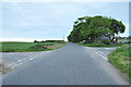
Road junctions near Outhill Cottage, north of Rora
Image: © Steven Brown
Taken: 12 Jun 2010
0.18 miles
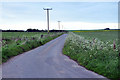
4
Ditch at the field boundary near Gowrie
Image: © Steven Brown
Taken: 12 Jun 2010
0.23 miles
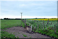
5
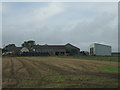
Burnhead Farm
between St Fergus Moss and Rora village
Image: © Ken Fitlike
Taken: 23 Oct 2006
0.24 miles