IMAGES TAKEN NEAR TO
St. Mary Terrace, PETERHEAD, AB42 4JX

Introduction

This page details the photographs taken nearby to St. Mary Terrace, AB42 4JX by members of the Geograph project.

The Geograph project started in 2005 with the aim of publishing, organising and preserving representative images for every square kilometre of Great Britain, Ireland and the Isle of Man.

There are currently over 7.5m images from over14,400 individuals and you can help contribute to the project by visiting https://www.geograph.org.uk

Image Map


Images are licensed for reuse under creativecommons.org/licenses/by-sa/2.0
Notes
  • Clicking on the map will re-center to the selected point.
  • The higher the marker number, the further away the image location is from the centre of the postcode.

Image Listing (9 Images Found)

Images are licensed for reuse under creativecommons.org/licenses/by-sa/2.0
Image
Details
Distance
1
House on St Mary Terrace, New Leeds
Image: © JThomas Taken: 22 Aug 2020
0.00 miles
2
Workshop, New Leeds
Image: © JThomas Taken: 22 Aug 2020
0.04 miles
3
New Leeds scene
New Leeds was established as a planned village in 1798, but as the Buildings of Scotland (Pevsner) Guide drily put it, growth has been 'glacial' since then and the village has a distinctly 'unfinished' feel to it in terms of un-metalled roads and dead-ends.
Image: © Bill Harrison Taken: 19 Apr 2016
0.05 miles
4
Bus stop on the A952, New Leeds
Image: © JThomas Taken: 22 Aug 2020
0.06 miles
5
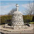
New Leeds war memorial
Four men lost in WWI, one man lost in WWII.
Image: © Bill Harrison Taken: 19 Apr 2016
0.07 miles
6
War Memorial at New Leeds
...this Memorial has a much more impressive view from the left hand side of this shot - downhill, which dramatically makes the observer see the cross against the sky - unfortunately this angle was negated by the sun shining directly into shot
Image: © Ken Fitlike Taken: 12 Apr 2007
0.09 miles
7
War Memorial, New Leeds
Image: © Ken Fitlike Taken: 12 Apr 2007
0.11 miles
8
New Leeds from the air
Taken from a plane flying between Sumburgh and Aberdeen. Mormont Hill is the wooded area centre top.
Image: © Mike Pennington Taken: 23 Jan 2017
0.12 miles
9
Wind farm
Image: © Alex McGregor Taken: 30 Sep 2015
0.22 miles