IMAGES TAKEN NEAR TO
Kininmonth, PETERHEAD, AB42 4JW
Introduction
This page details the photographs taken nearby to AB42 4JW by members of the Geograph project.
The Geograph project started in 2005 with the aim of publishing, organising and preserving representative images for every square kilometre of Great Britain, Ireland and the Isle of Man.

There are currently over 7.5m images from over14,400 individuals and you can help contribute to the project by visiting https://www.geograph.org.uk
Image Map
Images are licensed for reuse under creativecommons.org/licenses/by-sa/2.0
Notes
- Clicking on the map will re-center to the selected point.
- The higher the marker number, the further away the image location is from the centre of the postcode.
Image Listing (8 Images Found)
Images are licensed for reuse under creativecommons.org/licenses/by-sa/2.0
Image
Details
Distance
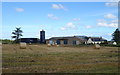
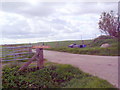
3
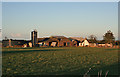
West Lochhills
An extensive range of outbuildings suggests that this is a livestock farm.
Image: © Anne Burgess
Taken: 6 Jan 2015
0.03 miles
5
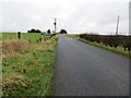
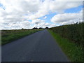
Road near the access to West Lochills
Looking south-westward.
Image: © Peter Wood
Taken: 22 Nov 2019
0.07 miles