IMAGES TAKEN NEAR TO
Fetterangus, PETERHEAD, AB42 4HB
Introduction
This page details the photographs taken nearby to AB42 4HB by members of the Geograph project.
The Geograph project started in 2005 with the aim of publishing, organising and preserving representative images for every square kilometre of Great Britain, Ireland and the Isle of Man.

There are currently over 7.5m images from over14,400 individuals and you can help contribute to the project by visiting https://www.geograph.org.uk
Image Map
Images are licensed for reuse under creativecommons.org/licenses/by-sa/2.0
Notes
- Clicking on the map will re-center to the selected point.
- The higher the marker number, the further away the image location is from the centre of the postcode.
Image Listing (5 Images Found)
Images are licensed for reuse under creativecommons.org/licenses/by-sa/2.0
Image
Details
Distance
1
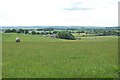
Standing stone by Gavel
Looking back towards Fetterangus. Just visible is a large standing stone
Image: © Jim Bain
Taken: 18 Jun 2006
0.03 miles
2
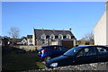
Fetterangus primary school
On an odd site set back from the road behind private gardens. School roll (2020): 41.
Image: © Bill Harrison
Taken: 22 Feb 2020
0.18 miles
3
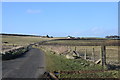
Looking down the road...
with Braeside of Fetterangus and Braeside of Gaval crofts visible in the distance.
Image: © Bill Harrison
Taken: 22 Feb 2020
0.24 miles
4
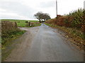
Minor road at the entrance to Braeside of Gaval
Looking northward.
Image: © Peter Wood
Taken: 22 Nov 2019
0.24 miles
5
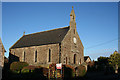
Fetterangus Parish Kirk
Fetterangus belongs to the parish of Old Deer, and did not get its own kirk until the 19th century, to provide services for the growing population of the village. It isn't marked on the first edition of the Ordnance Survey six-inch map, which was surveyed in 1869-70, but it is on all the later maps. That, and the style of building, both indicate that it was built in the latter part of the 19th century, but the exact date of construction appears to be unknown.
Image: © Anne Burgess
Taken: 6 Jan 2015
0.25 miles