IMAGES TAKEN NEAR TO
Boddam, PETERHEAD, AB42 3PB
Introduction
This page details the photographs taken nearby to AB42 3PB by members of the Geograph project.
The Geograph project started in 2005 with the aim of publishing, organising and preserving representative images for every square kilometre of Great Britain, Ireland and the Isle of Man.

There are currently over 7.5m images from over14,400 individuals and you can help contribute to the project by visiting https://www.geograph.org.uk
Image Map
Images are licensed for reuse under creativecommons.org/licenses/by-sa/2.0
Notes
- Clicking on the map will re-center to the selected point.
- The higher the marker number, the further away the image location is from the centre of the postcode.
Image Listing (3 Images Found)
Images are licensed for reuse under creativecommons.org/licenses/by-sa/2.0
Image
Details
Distance
1

Water-filled quarry, Stirling Hill
Probably very deep...
Image: © Bill Harrison
Taken: 10 Jun 2022
0.23 miles
2
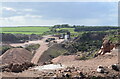
Stirling Hill Quarry
Quarrying nearer to the coast has ceased but this granite quarry is still very much active.
Image: © Bill Harrison
Taken: 10 Jun 2022
0.25 miles
3
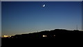
Stirling Hill at Twilight
Stirling Hill (nowhere near Stirling by the way) silhouetted against the skyline as the sun goes down.
Image: © Iain Smith
Taken: 6 Jan 2011
0.25 miles