IMAGES TAKEN NEAR TO
Blackhills, PETERHEAD, AB42 3LR
Introduction
This page details the photographs taken nearby to AB42 3LR by members of the Geograph project.
The Geograph project started in 2005 with the aim of publishing, organising and preserving representative images for every square kilometre of Great Britain, Ireland and the Isle of Man.

There are currently over 7.5m images from over14,400 individuals and you can help contribute to the project by visiting https://www.geograph.org.uk
Image Map
Images are licensed for reuse under creativecommons.org/licenses/by-sa/2.0
Notes
- Clicking on the map will re-center to the selected point.
- The higher the marker number, the further away the image location is from the centre of the postcode.
Image Listing (5 Images Found)
Images are licensed for reuse under creativecommons.org/licenses/by-sa/2.0
Image
Details
Distance
1
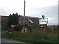
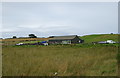
Oldtown of Meikle Dens Farm
the tractor seems to be a static ornamental landmark rather than a functioning piece of equipment
Image: © Ken Fitlike
Taken: 15 Sep 2006
0.06 miles
3
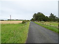
Minor road near Glendale
Towards Peterhead.
Image: © JThomas
Taken: 23 Aug 2020
0.13 miles
4

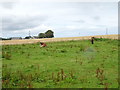
Hillside grazing near Oldtown of Meikle Dens
Image: © JThomas
Taken: 23 Aug 2020
0.20 miles