IMAGES TAKEN NEAR TO
Blackhills, PETERHEAD, AB42 3LQ
Introduction
This page details the photographs taken nearby to AB42 3LQ by members of the Geograph project.
The Geograph project started in 2005 with the aim of publishing, organising and preserving representative images for every square kilometre of Great Britain, Ireland and the Isle of Man.

There are currently over 7.5m images from over14,400 individuals and you can help contribute to the project by visiting https://www.geograph.org.uk
Image Map
Images are licensed for reuse under creativecommons.org/licenses/by-sa/2.0
Notes
- Clicking on the map will re-center to the selected point.
- The higher the marker number, the further away the image location is from the centre of the postcode.
Image Listing (4 Images Found)
Images are licensed for reuse under creativecommons.org/licenses/by-sa/2.0
Image
Details
Distance
3
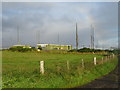
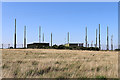
Military Transmitter Station
As the site is unmarked on the Ordnance Survey map, this Geographer is unsure if this image is acceptable to Geograph.org.uk!
Fingers crossed I don't receive a midnight knock from the MOD
Image: © Ken Fitlike
Taken: 15 May 2007
0.23 miles
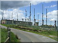
4
Military Installation
I believe this to be a transmitter of some kind.
Image: © Anne Burgess
Taken: 26 Aug 2019
0.23 miles