IMAGES TAKEN NEAR TO
Blackhills, PETERHEAD, AB42 3LN
Introduction
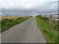
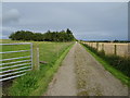
This page details the photographs taken nearby to AB42 3LN by members of the Geograph project.
The Geograph project started in 2005 with the aim of publishing, organising and preserving representative images for every square kilometre of Great Britain, Ireland and the Isle of Man.

There are currently over 7.5m images from over14,400 individuals and you can help contribute to the project by visiting https://www.geograph.org.uk
Image Map
Images are licensed for reuse under creativecommons.org/licenses/by-sa/2.0
Notes
- Clicking on the map will re-center to the selected point.
- The higher the marker number, the further away the image location is from the centre of the postcode.
Image Listing (6 Images Found)
Images are licensed for reuse under creativecommons.org/licenses/by-sa/2.0
Image
Details
Distance
5
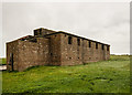
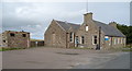
RAF Cocklaw, WWII Chain Home Low radar station (1)
-
Chain Home Low Station: EDoB ID: e25256
Transmitter/Receiver Block
Chain Home Low radar was introduced to overcome the significant gaps in low level cover of the standard Chain Home radar system. CHL was effective at detecting aircraft below about 500 feet, and unlike CH radar, used a rotating antenna often mounted on the roof of the Tx/Rx building. The CHL station at Cocklaw opened in 1941 and was still in operation in 1945. The large concrete block seen on the roof of the Tx/Rx block presumably was the plinth on which the antenna was mounted.
Image
Image: © Mike Searle
Taken: 17 Sep 2018
0.19 miles
6
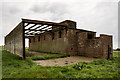
RAF Cocklaw, WWII Chain Home Low radar station (2)
-
Chain Home Low Station: EDoB ID: e25256
Transmitter/Receiver Block
The attached roofless structure is a postwar add-on.
Image: © Mike Searle
Taken: 17 Sep 2018
0.19 miles