IMAGES TAKEN NEAR TO
Blackhills, PETERHEAD, AB42 3LA
Introduction
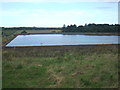
This page details the photographs taken nearby to AB42 3LA by members of the Geograph project.
The Geograph project started in 2005 with the aim of publishing, organising and preserving representative images for every square kilometre of Great Britain, Ireland and the Isle of Man.

There are currently over 7.5m images from over14,400 individuals and you can help contribute to the project by visiting https://www.geograph.org.uk
Image Map
Images are licensed for reuse under creativecommons.org/licenses/by-sa/2.0
Notes
- Clicking on the map will re-center to the selected point.
- The higher the marker number, the further away the image location is from the centre of the postcode.
Image Listing (2 Images Found)
Images are licensed for reuse under creativecommons.org/licenses/by-sa/2.0
Image
Details
Distance
1
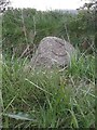
Old Milestone by the A950, Longside Road, Peterhead parish
Aberdeen granite by the A950, in parish of Peterhead (Aberdeen District), 50m East of road signed 'Blackhill', on verge, South side of road.
Inscription reads:-
3
(To Peterhead)
Surveyed
Milestone Society National ID: AD_PHNP03
Image: © Milestone Society
Taken: Unknown
0.22 miles