IMAGES TAKEN NEAR TO
Rattray, PETERHEAD, AB42 3EU
Introduction
This page details the photographs taken nearby to AB42 3EU by members of the Geograph project.
The Geograph project started in 2005 with the aim of publishing, organising and preserving representative images for every square kilometre of Great Britain, Ireland and the Isle of Man.

There are currently over 7.5m images from over14,400 individuals and you can help contribute to the project by visiting https://www.geograph.org.uk
Image Map
Images are licensed for reuse under creativecommons.org/licenses/by-sa/2.0
Notes
- Clicking on the map will re-center to the selected point.
- The higher the marker number, the further away the image location is from the centre of the postcode.
Image Listing (4 Images Found)
Images are licensed for reuse under creativecommons.org/licenses/by-sa/2.0
Image
Details
Distance
1
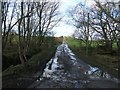
farm track off the Rattray Road
an example of country roads where the big 4 wheel drive vehicles come into their own!
Image: © Ken Fitlike
Taken: 6 Feb 2007
0.07 miles
2
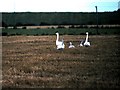
An overwintering family of Whooper Swans
A family of two adults and three young that had just arrived from their breeding grounds in the Arctic, feeding on stubble near Loch of Strathbeg.
Image: © Stanley Howe
Taken: 12 Oct 1978
0.19 miles