IMAGES TAKEN NEAR TO
St. Fergus, PETERHEAD, AB42 3EN
Introduction
This page details the photographs taken nearby to AB42 3EN by members of the Geograph project.
The Geograph project started in 2005 with the aim of publishing, organising and preserving representative images for every square kilometre of Great Britain, Ireland and the Isle of Man.

There are currently over 7.5m images from over14,400 individuals and you can help contribute to the project by visiting https://www.geograph.org.uk
Image Map
Images are licensed for reuse under creativecommons.org/licenses/by-sa/2.0
Notes
- Clicking on the map will re-center to the selected point.
- The higher the marker number, the further away the image location is from the centre of the postcode.
Image Listing (6 Images Found)
Images are licensed for reuse under creativecommons.org/licenses/by-sa/2.0
Image
Details
Distance
1
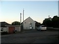
St Fergus telephone exchange
The St Fergus telephone exchange is situated at Inverquinzie, a mile south of the village of St Fergus.
Image: © Haworth Hodgkinson
Taken: 9 Oct 2016
0.02 miles
2
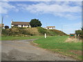
Inverquinzie Cottages
prominent set of former farm 'cotter hooses' at a road bend one mile south of St Fergus
Image: © Ken Fitlike
Taken: 19 Sep 2006
0.05 miles
3
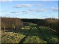
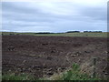
track through trees near St Fergus
previously poor boggy marginal farming land, planted with trees 20-25 years ago. now used as shooting estate
Image: © Ken Fitlike
Taken: 6 Feb 2007
0.19 miles