IMAGES TAKEN NEAR TO
Inverugie, PETERHEAD, AB42 3DU
Introduction
This page details the photographs taken nearby to AB42 3DU by members of the Geograph project.
The Geograph project started in 2005 with the aim of publishing, organising and preserving representative images for every square kilometre of Great Britain, Ireland and the Isle of Man.

There are currently over 7.5m images from over14,400 individuals and you can help contribute to the project by visiting https://www.geograph.org.uk
Image Map
Images are licensed for reuse under creativecommons.org/licenses/by-sa/2.0
Notes
- Clicking on the map will re-center to the selected point.
- The higher the marker number, the further away the image location is from the centre of the postcode.
Image Listing (6 Images Found)
Images are licensed for reuse under creativecommons.org/licenses/by-sa/2.0
Image
Details
Distance
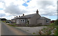
2
Minor road, Westerton of Barnyards
Towards Smiddyhill.
Image: © JThomas
Taken: 24 Aug 2020
0.18 miles
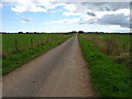
4
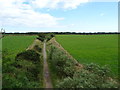
Formartine and Buchan Way towards Peterhead
Popular leisure route on the disused railway.
Image: © JThomas
Taken: 24 Aug 2020
0.23 miles
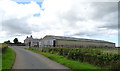
5
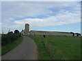
Easterton of Barnyards
large cattle sheds and concrete grain silo
Image: © Ken Fitlike
Taken: 2 Sep 2006
0.23 miles