IMAGES TAKEN NEAR TO
Boddam, PETERHEAD, AB42 3AE
Introduction
This page details the photographs taken nearby to AB42 3AE by members of the Geograph project.
The Geograph project started in 2005 with the aim of publishing, organising and preserving representative images for every square kilometre of Great Britain, Ireland and the Isle of Man.

There are currently over 7.5m images from over14,400 individuals and you can help contribute to the project by visiting https://www.geograph.org.uk
Image Map
Images are licensed for reuse under creativecommons.org/licenses/by-sa/2.0
Notes
- Clicking on the map will re-center to the selected point.
- The higher the marker number, the further away the image location is from the centre of the postcode.
Image Listing (4 Images Found)
Images are licensed for reuse under creativecommons.org/licenses/by-sa/2.0
Image
Details
Distance
1
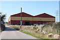
Ian Davidson Building
This is one of several buildings in the area belonging to the Score Group plc https://score-group.com/ and is named after a prominent member of staff https://score-group.com/news/2011/10/score-honour-ian-davidson/.
Image: © Anne Burgess
Taken: 26 Aug 2019
0.04 miles
3

Score Engineering Turbine Plant
A very impressive 'ornament' displayed outside the facility!
Image: © Ken Fitlike
Taken: 1 Nov 2006
0.22 miles