IMAGES TAKEN NEAR TO
South Road, PETERHEAD, AB42 2XX
Introduction
This page details the photographs taken nearby to South Road, AB42 2XX by members of the Geograph project.
The Geograph project started in 2005 with the aim of publishing, organising and preserving representative images for every square kilometre of Great Britain, Ireland and the Isle of Man.

There are currently over 7.5m images from over14,400 individuals and you can help contribute to the project by visiting https://www.geograph.org.uk
Image Map
Images are licensed for reuse under creativecommons.org/licenses/by-sa/2.0
Notes
- Clicking on the map will re-center to the selected point.
- The higher the marker number, the further away the image location is from the centre of the postcode.
Image Listing (27 Images Found)
Images are licensed for reuse under creativecommons.org/licenses/by-sa/2.0
Image
Details
Distance
6
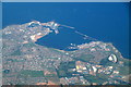
Peterhead from the air
Taken from a flight between Aberdeen and Shetland.
Image: © Mike Pennington
Taken: 31 Aug 2018
0.11 miles

9

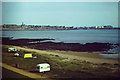
Sunset over Peterhead
The sun goes down over Peterhead, as viewed from a jetty in the bay.
Image: © Iain Smith
Taken: 30 Aug 2010
0.16 miles
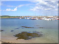
10
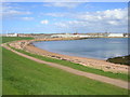
Peterhead Bay
East-facing bay at the Lido, south of the town centre.
Image: © Colin Smith
Taken: Unknown
0.17 miles