IMAGES TAKEN NEAR TO
Henderson Circle, PETERHEAD, AB42 2UG
Introduction
This page details the photographs taken nearby to Henderson Circle, AB42 2UG by members of the Geograph project.
The Geograph project started in 2005 with the aim of publishing, organising and preserving representative images for every square kilometre of Great Britain, Ireland and the Isle of Man.

There are currently over 7.5m images from over14,400 individuals and you can help contribute to the project by visiting https://www.geograph.org.uk
Image Map
Images are licensed for reuse under creativecommons.org/licenses/by-sa/2.0
Notes
- Clicking on the map will re-center to the selected point.
- The higher the marker number, the further away the image location is from the centre of the postcode.
Image Listing (5 Images Found)
Images are licensed for reuse under creativecommons.org/licenses/by-sa/2.0
Image
Details
Distance
1
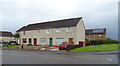
Houses on Richmond Avenue, Coplandhill, Peterhead
Image: © JThomas
Taken: 22 Aug 2020
0.10 miles
2
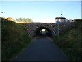
Richmond Avenue bridge over the Formartine and Buchan Way
Image: © JThomas
Taken: 24 Aug 2020
0.15 miles
3
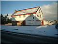
Peterhead, West Road
Grange Inn in all its winter glory
Image: © Ken Fitlike
Taken: 29 Dec 2002
0.18 miles
4
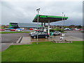
Supermarket service station, Coplandhill, Peterhead
Image: © JThomas
Taken: 22 Aug 2020
0.20 miles
