IMAGES TAKEN NEAR TO
Petergrange Road, PETERHEAD, AB42 2AZ
Introduction
This page details the photographs taken nearby to Petergrange Road, AB42 2AZ by members of the Geograph project.
The Geograph project started in 2005 with the aim of publishing, organising and preserving representative images for every square kilometre of Great Britain, Ireland and the Isle of Man.

There are currently over 7.5m images from over14,400 individuals and you can help contribute to the project by visiting https://www.geograph.org.uk
Image Map
Images are licensed for reuse under creativecommons.org/licenses/by-sa/2.0
Notes
- Clicking on the map will re-center to the selected point.
- The higher the marker number, the further away the image location is from the centre of the postcode.
Image Listing (8 Images Found)
Images are licensed for reuse under creativecommons.org/licenses/by-sa/2.0
Image
Details
Distance

3
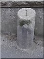
Old Milestone by the A950, West Road, Peterhead
Aberdeen granite by the A950, West Road, in parish of Peterhead (Aberdeen District), near to junction with Eden Grove, on pavement, South side of road. Possibly relocated from further West when roundabout was installed.
Inscription reads:-
1
(To Peterhead)
Surveyed
Milestone Society National ID: AD_PHNP01
Image: © Milestone Society
Taken: Unknown
0.12 miles
4
Peterhead, West Road
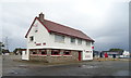
Grange Inn in all its winter glory
Image: © Ken Fitlike
Taken: 29 Dec 2002
0.18 miles
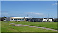
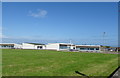
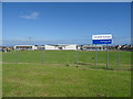
8
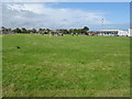
Playing fields, Clerkhill Primary School, Peterhead
Image: © JThomas
Taken: 21 Aug 2020
0.22 miles