IMAGES TAKEN NEAR TO
Love Lane, PETERHEAD, AB42 1PT
Introduction
This page details the photographs taken nearby to Love Lane, AB42 1PT by members of the Geograph project.
The Geograph project started in 2005 with the aim of publishing, organising and preserving representative images for every square kilometre of Great Britain, Ireland and the Isle of Man.

There are currently over 7.5m images from over14,400 individuals and you can help contribute to the project by visiting https://www.geograph.org.uk
Image Map
Images are licensed for reuse under creativecommons.org/licenses/by-sa/2.0
Notes
- Clicking on the map will re-center to the selected point.
- The higher the marker number, the further away the image location is from the centre of the postcode.
Image Listing (216 Images Found)
Images are licensed for reuse under creativecommons.org/licenses/by-sa/2.0
Image
Details
Distance
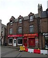
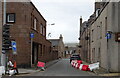
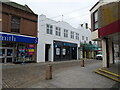
1
Side street, Peterhead
A massive late 18th Century granite block at the corner of Maiden Street and Love Lane. In the left background is the spire of St Peter Kirk.
Image: © Bill Harrison
Taken: 27 Jun 2015
0.01 miles
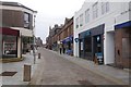
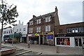
2
Love Lane, Peterhead
Off Erroll Street leads down to the harbour.
Image: © JThomas
Taken: 25 Aug 2020
0.01 miles
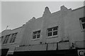
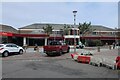
5
Brewdog pub, Peterhead
On Marischal Street.
Image: © JThomas
Taken: 21 Aug 2020
0.02 miles
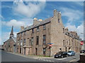
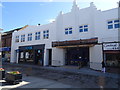
6
Brewdog Public House on Marischal Street, Peterhead
Image: © JThomas
Taken: 25 Aug 2020
0.03 miles