IMAGES TAKEN NEAR TO
Blackhouse Terrace, PETERHEAD, AB42 1LQ
Introduction
This page details the photographs taken nearby to Blackhouse Terrace, AB42 1LQ by members of the Geograph project.
The Geograph project started in 2005 with the aim of publishing, organising and preserving representative images for every square kilometre of Great Britain, Ireland and the Isle of Man.

There are currently over 7.5m images from over14,400 individuals and you can help contribute to the project by visiting https://www.geograph.org.uk
Image Map
Images are licensed for reuse under creativecommons.org/licenses/by-sa/2.0
Notes
- Clicking on the map will re-center to the selected point.
- The higher the marker number, the further away the image location is from the centre of the postcode.
Image Listing (20 Images Found)
Images are licensed for reuse under creativecommons.org/licenses/by-sa/2.0
Image
Details
Distance
4
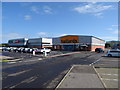
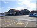
Out of town shops
A mix of shops here including Halfords, Homebargains and Lidl
Image: © Ralph Greig
Taken: 8 Mar 2023
0.18 miles
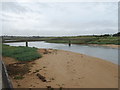
7
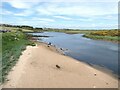
River Ugie
Looking upstream from the George Birnie Footbridge.
Image: © Oliver Dixon
Taken: 10 Jun 2021
0.21 miles
8
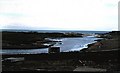
Ugie estuary, Peterhead (1978)
Peterhead golf course on the left bank.
Image: © Stanley Howe
Taken: Unknown
0.21 miles
9
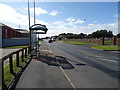
Bus stop and shelter on Windmill Road, Peterhead
Image: © JThomas
Taken: 21 Aug 2020
0.22 miles
10
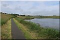
The George Birnie Memorial Bridge
Over the River Ugie, giving access to the Golf Club and coastal path.
Image: © JThomas
Taken: 21 Aug 2020
0.22 miles