IMAGES TAKEN NEAR TO
Windmill Street, PETERHEAD, AB42 1LG
Introduction
This page details the photographs taken nearby to Windmill Street, AB42 1LG by members of the Geograph project.
The Geograph project started in 2005 with the aim of publishing, organising and preserving representative images for every square kilometre of Great Britain, Ireland and the Isle of Man.

There are currently over 7.5m images from over14,400 individuals and you can help contribute to the project by visiting https://www.geograph.org.uk
Image Map
Images are licensed for reuse under creativecommons.org/licenses/by-sa/2.0
Notes
- Clicking on the map will re-center to the selected point.
- The higher the marker number, the further away the image location is from the centre of the postcode.
Image Listing (210 Images Found)
Images are licensed for reuse under creativecommons.org/licenses/by-sa/2.0
Image
Details
Distance
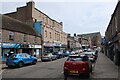
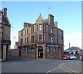
1
Former Fire Station, Peterhead
On Windmill Street.
Image: © JThomas
Taken: 21 Aug 2020
0.01 miles
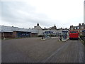
3

Stagecoach bus at Peterhead Interchange
'The Buchan Link'.
Image: © John Lucas
Taken: 9 Sep 2015
0.05 miles
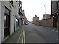
6
Recruitment agency on Ellis Street, Peterhead
Showing position of Postbox No. AB42 4.
See Image] for postbox.
Image: © JThomas
Taken: 25 Aug 2020
0.06 miles
7
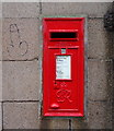
George VI postbox on Ellis Street, Peterhead
Postbox No. AB42 4.
See Image] for context.
Image: © JThomas
Taken: 25 Aug 2020
0.07 miles
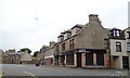
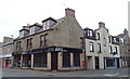
8
The Harbour Lights, Peterhead
Bar on Longate.
Image: © JThomas
Taken: 24 Aug 2020
0.07 miles