IMAGES TAKEN NEAR TO
Hay Crescent, PETERHEAD, AB42 1HH
Introduction
This page details the photographs taken nearby to Hay Crescent, AB42 1HH by members of the Geograph project.
The Geograph project started in 2005 with the aim of publishing, organising and preserving representative images for every square kilometre of Great Britain, Ireland and the Isle of Man.

There are currently over 7.5m images from over14,400 individuals and you can help contribute to the project by visiting https://www.geograph.org.uk
Image Map
Images are licensed for reuse under creativecommons.org/licenses/by-sa/2.0
Notes
- Clicking on the map will re-center to the selected point.
- The higher the marker number, the further away the image location is from the centre of the postcode.
Image Listing (23 Images Found)
Images are licensed for reuse under creativecommons.org/licenses/by-sa/2.0
Image
Details
Distance
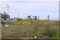
7
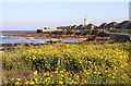
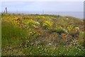
Wildflowers at The Gadle
So much more attractive than a swathe of boring mown grass!
Image: © Anne Burgess
Taken: 26 Aug 2019
0.15 miles
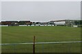
9
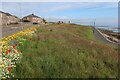
Seafront at Peterhead
With a sensible mix of pretty but largely non-native plants at the top and less pretty grass and yellow rattle further down giving more wildlife value to the area.
Image: © Hugh Venables
Taken: 14 Jul 2023
0.16 miles