IMAGES TAKEN NEAR TO
Dickie Drive, PETERHEAD, AB42 1HB
Introduction
This page details the photographs taken nearby to Dickie Drive, AB42 1HB by members of the Geograph project.
The Geograph project started in 2005 with the aim of publishing, organising and preserving representative images for every square kilometre of Great Britain, Ireland and the Isle of Man.

There are currently over 7.5m images from over14,400 individuals and you can help contribute to the project by visiting https://www.geograph.org.uk
Image Map
Images are licensed for reuse under creativecommons.org/licenses/by-sa/2.0
Notes
- Clicking on the map will re-center to the selected point.
- The higher the marker number, the further away the image location is from the centre of the postcode.
Image Listing (18 Images Found)
Images are licensed for reuse under creativecommons.org/licenses/by-sa/2.0
Image
Details
Distance
1
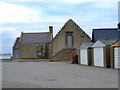
Salmon Smoke House
The oldest building in Peterhead, dating back to 1585. Still working, and operated by Ugie Salmon Fishings, this is probably the oldest working premises in Scotland.
Image: © Iain Smith
Taken: 23 Jul 2009
0.10 miles
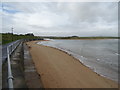
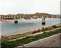
3
River Ugie entering the sea
From the George Birnie Memorial Bridge.
Image: © JThomas
Taken: 21 Aug 2020
0.16 miles
4
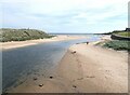
Mouth of the River Ugie
Seen from the George Birnie footbridge.
Image: © Oliver Dixon
Taken: 10 Jun 2021
0.17 miles
5
George Birnie Memorial Bridge
This is the original bridge, first proposed in June 1924 by Alexander Birnie and dedicated to his father, George Birnie who was harbour master at Peterhead.
The bridge has since been demolished and replaced.
Image: © Iain Smith
Taken: Unknown
0.17 miles
6
The George Birnie Memorial Bridge
footbridge over the River Ugie is the only access from town to Peterhead Golf Course. Modern structure replaced the previous bridge about 1990
Image: © Ken Fitlike
Taken: 1 Jan 2006
0.18 miles
7
The George Birnie Memorial Bridge
Over the River Ugie, giving access to the Golf Club and coastal path.
Image: © JThomas
Taken: 21 Aug 2020
0.19 miles
8
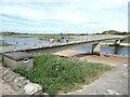
George Birnie Memorial footbridge
Linking the town of Peterhead with the golf club and beaches to the north.
Not the original 1924 bridge mentioned in the adjacent commemorative plaque but a more modern replacement.
Image: © Oliver Dixon
Taken: 10 Jun 2021
0.19 miles
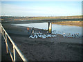
9
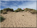
Peterhead Golf Clubhouse Midden
Peterhead Golf Club was established in 1841. After the first clubhouse burned down, a new clubhouse was opened in 1887.
Rubbish from the clubhouse was simply dumped in the dunes, and apparently burnt. In recent years, erosion has been exposing the contents of this midden.
Whilst much of the remains coming to light consist in the main of broken glass and crockery, occasionally complete artifacts appear, and I have recovered a Gordon's gin bottle dating from around 1912, and a Long John whisky bottle, dating from around 1924.
Other incomplete finds include beer bottles from Hunter & Sons of Peterhead, and Heslop & Son of Peterhead. Faded beer bottle caps reveal that Hunter & Son took advantage of the new fangled telephone apparatus; Peterhead 150 was their phone number.
Image: © Iain Smith
Taken: 10 Aug 2010
0.19 miles
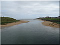
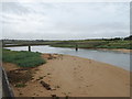
10
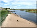
River Ugie
Looking upstream from the George Birnie Footbridge.
Image: © Oliver Dixon
Taken: 10 Jun 2021
0.20 miles