IMAGES TAKEN NEAR TO
Hatton, PETERHEAD, AB42 0SN
Introduction
This page details the photographs taken nearby to AB42 0SN by members of the Geograph project.
The Geograph project started in 2005 with the aim of publishing, organising and preserving representative images for every square kilometre of Great Britain, Ireland and the Isle of Man.

There are currently over 7.5m images from over14,400 individuals and you can help contribute to the project by visiting https://www.geograph.org.uk
Image Map
Images are licensed for reuse under creativecommons.org/licenses/by-sa/2.0
Notes
- Clicking on the map will re-center to the selected point.
- The higher the marker number, the further away the image location is from the centre of the postcode.
Image Listing (2 Images Found)
Images are licensed for reuse under creativecommons.org/licenses/by-sa/2.0
Image
Details
Distance
1
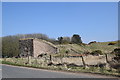
Remains of the Boddam branch
The branch line from Ellon to Boddam was constructed in 1897 to serve the hotel at Cruden Bay but passenger services were abandoned as early as 1932 due to lack of traffic and the line was lifted in 1950: https://en.wikipedia.org/wiki/Boddam_Branch .
Image: © Bill Harrison
Taken: 15 Apr 2018
0.07 miles
2
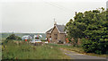
Cruden Bay station (remains), 1988
View westward, towards Ellon: ex-GNSR Ellon - Boddam branch, closed throughout to passengers from 31/10/32, to freight 7/11/45. Before World War Two an electric tramway used to run from the station to Cruden Bay Hotel, but the hotel and tramway, also the whole branch, were taken over by the Military in 1941.
Image: © Ben Brooksbank
Taken: 20 Jun 1988
0.21 miles