IMAGES TAKEN NEAR TO
Hatton, PETERHEAD, AB42 0SL
Introduction
This page details the photographs taken nearby to AB42 0SL by members of the Geograph project.
The Geograph project started in 2005 with the aim of publishing, organising and preserving representative images for every square kilometre of Great Britain, Ireland and the Isle of Man.

There are currently over 7.5m images from over14,400 individuals and you can help contribute to the project by visiting https://www.geograph.org.uk
Image Map
Images are licensed for reuse under creativecommons.org/licenses/by-sa/2.0
Notes
- Clicking on the map will re-center to the selected point.
- The higher the marker number, the further away the image location is from the centre of the postcode.
Image Listing (9 Images Found)
Images are licensed for reuse under creativecommons.org/licenses/by-sa/2.0
Image
Details
Distance
1
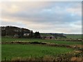
Midmill Farm
An arable farm near Bridgend.
Image: © Andrew Wood
Taken: 18 Nov 2018
0.01 miles
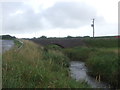
4
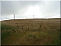
Hillside cereal crop and turbines
Near Midmill.
Image: © JThomas
Taken: 23 Aug 2020
0.12 miles
5
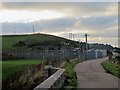
Bridgend Substation
An electrical substation by the A90 at Bridgend tucked in land by the old bridge.
Image: © Andrew Wood
Taken: 18 Nov 2018
0.16 miles
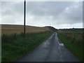
6
Bridge over the Water of Cruden
Once the main road, now by-passed by the A90.
Image: © JThomas
Taken: 23 Aug 2020
0.18 miles
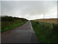
7
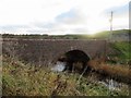
Old Bridge at Bridgend
The old bridge over the Water of Cruden at Bridgend. It was replaced by a newer one on a road realignment.
Image: © Andrew Wood
Taken: 18 Nov 2018
0.18 miles
8
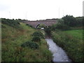
A90 bridge over the Water of Cruden
From the old bridge.
Image: © JThomas
Taken: 23 Aug 2020
0.22 miles
9
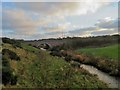
Water of Cruden
The Water of Cruden flowing east toward the A90 road bridge at Bridgend.
Image: © Andrew Wood
Taken: 18 Nov 2018
0.23 miles