IMAGES TAKEN NEAR TO
Cruden Bay, PETERHEAD, AB42 0QH
Introduction
This page details the photographs taken nearby to AB42 0QH by members of the Geograph project.
The Geograph project started in 2005 with the aim of publishing, organising and preserving representative images for every square kilometre of Great Britain, Ireland and the Isle of Man.

There are currently over 7.5m images from over14,400 individuals and you can help contribute to the project by visiting https://www.geograph.org.uk
Image Map
Images are licensed for reuse under creativecommons.org/licenses/by-sa/2.0
Notes
- Clicking on the map will re-center to the selected point.
- The higher the marker number, the further away the image location is from the centre of the postcode.
Image Listing (19 Images Found)
Images are licensed for reuse under creativecommons.org/licenses/by-sa/2.0
Image
Details
Distance
1
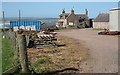
East Sandend
The farm house is just in square, and the buildings are in the next square. The Bay of Cruden is beyond.
Image: © Anne Burgess
Taken: 2 Jul 2010
0.01 miles
2
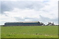
East Sandend Farm under changeable skies
Image: © Bill Harrison
Taken: 13 Jun 2021
0.03 miles
3
Whinnyfold: Scotland's third oil boom
Just under my feet there is a major pipeline bringing ashore Scotland's oil. The complex Forties pipeline system carries about 700 thousand barrels per day, 30% of the UK's oil. It is owned and operated by UK-based global energy company BP. The system, which consists of a 36-inch pipeline originating at the Forties Charlie platform, carries crude oil 169 kilometres to the Cruden Bay pumping station, mile or so from here. From there, the crude flows a further 209 km south to the processing facility at Grangemouth on the Firth of Forth.
North Sea oil is in fact Scotland's third oil industry. The first was based not on petroleum oil but on whale oil. In the 18th and 19th centuries whalers sailed to Greenland from Scottish ports, particularly Dundee, Aberdeen and Peterhead. There they harpooned Bowhead whales and brought back their blubber in barrels. The blubber was boiled back in Scotland and the oil used for a range of purposes including street lighting and textile and jute manufacture.
The second oil industry came about thanks to one James 'Paraffin' Young. In 1851 he began to distil oil, at first from coal and later from rock shales, near to Bathgate, in West Lothian. This was the foundation of the modern oil industry, providing the raw material for a new range of chemicals. His legacy can still be seen in the landscape of West Lothian in the form of huge red mounds or bings, of spent shale from which oil has been extracted Image
Image: © Martyn Gorman
Taken: 21 Mar 2011
0.07 miles
4
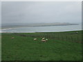
sheep grazing, Sandend Farm
near Whinnyfold. Location of this snap gives a better than usual perspective of the 'Bay' aspect of Cruden Bay. Brooding ruin of Slains Castle to the right
Image: © Ken Fitlike
Taken: 18 Oct 2006
0.12 miles
5
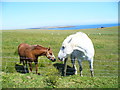
Clifftop Pasture, Whinnyfold
Horses, and a few sheep, were grazing on the fields high above Cruden Bay.
Image: © Colin Smith
Taken: 8 Aug 2009
0.15 miles
6

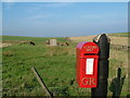
Post Box
This is a closer view of Image I have never before noticed a post box with GR on it but no indication of which King George was the one in question. I am grateful to James Yardley who tells me that it is most likely to have been George V, because post boxes had not been invented by the time of George IV.
Image: © Anne Burgess
Taken: 2 Jul 2010
0.15 miles
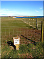
7
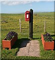
Post Box at Whinnyfold
Whinnyfold isn't troubled by much in the way of public amenities apart from street lighting, water, sewerage, electricity and a well cared for post box. Post box enthusiasts may like to see a closer view Image
Image: © Anne Burgess
Taken: 2 Jul 2010
0.15 miles
8
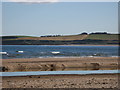
The chimneys of Whinnyfold seen from Cruden Bay
Image: © Ulrich Hartmann
Taken: 24 Aug 2007
0.16 miles
9
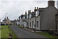
Whinnyfold
Former fishing village perched on a clifftop above a small bay.
Image: © Mike Pennington
Taken: 2 Aug 2012
0.16 miles
10
Postbox at Whinnyfold
Looking in the direction of Cruden Bay.
Image: © Richard Slessor
Taken: 17 Sep 2006
0.16 miles