IMAGES TAKEN NEAR TO
Cruden Bay, PETERHEAD, AB42 0PN
Introduction
This page details the photographs taken nearby to AB42 0PN by members of the Geograph project.
The Geograph project started in 2005 with the aim of publishing, organising and preserving representative images for every square kilometre of Great Britain, Ireland and the Isle of Man.

There are currently over 7.5m images from over14,400 individuals and you can help contribute to the project by visiting https://www.geograph.org.uk
Image Map
Images are licensed for reuse under creativecommons.org/licenses/by-sa/2.0
Notes
- Clicking on the map will re-center to the selected point.
- The higher the marker number, the further away the image location is from the centre of the postcode.
Image Listing (2 Images Found)
Images are licensed for reuse under creativecommons.org/licenses/by-sa/2.0
Image
Details
Distance
1
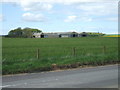
View towards West Teuchan
...from South Teuchan farm road end. Field of barley coming on well. A handsome collection of modern sheds.
Farm has 'High Health Pig Unit' signs on the road leading to it.
link for info.....
http://www.thepigsite.com/stockstds/14/herd-security-for-a-high-health-farm
Image: © Ken Fitlike
Taken: 15 May 2007
0.14 miles
2
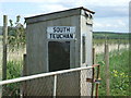
Bus Shelter at South Teuchan
Situated at the farm road end (South Teuchan is in the next grid square)
No commercial bus route on this back road but the kids would appreciate 'the hut that Dad made' on rainy mornings while waiting for the school bus.
Image: © Ken Fitlike
Taken: 15 May 2007
0.19 miles