IMAGES TAKEN NEAR TO
Cruden Bay, PETERHEAD, AB42 0PE
Introduction
This page details the photographs taken nearby to AB42 0PE by members of the Geograph project.
The Geograph project started in 2005 with the aim of publishing, organising and preserving representative images for every square kilometre of Great Britain, Ireland and the Isle of Man.

There are currently over 7.5m images from over14,400 individuals and you can help contribute to the project by visiting https://www.geograph.org.uk
Image Map
Images are licensed for reuse under creativecommons.org/licenses/by-sa/2.0
Notes
- Clicking on the map will re-center to the selected point.
- The higher the marker number, the further away the image location is from the centre of the postcode.
Image Listing (5 Images Found)
Images are licensed for reuse under creativecommons.org/licenses/by-sa/2.0
Image
Details
Distance
2
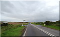
Crossroads on the A90
Turn right for Auchiries.
Image: © JThomas
Taken: 26 Aug 2020
0.07 miles
3
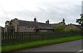
Crossroads at Auchiries
Minor roads cross the busy A92 Peterhead to Aberdeen road. Heavy oil industry related traffic make this an arduous journey most of the time, with lorry convoys testing the motorists' patience. The bungalow MUST have double-glazing!
Image: © Ken Fitlike
Taken: 1 Oct 2006
0.08 miles
5
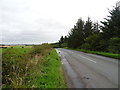
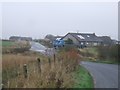
Country road, West Auchries
Towards Peterhead.
Image: © JThomas
Taken: 26 Aug 2020
0.15 miles