IMAGES TAKEN NEAR TO
Slains Avenue, ELLON, AB41 9ZA
Introduction
This page details the photographs taken nearby to Slains Avenue, AB41 9ZA by members of the Geograph project.
The Geograph project started in 2005 with the aim of publishing, organising and preserving representative images for every square kilometre of Great Britain, Ireland and the Isle of Man.

There are currently over 7.5m images from over14,400 individuals and you can help contribute to the project by visiting https://www.geograph.org.uk
Image Map
Images are licensed for reuse under creativecommons.org/licenses/by-sa/2.0
Notes
- Clicking on the map will re-center to the selected point.
- The higher the marker number, the further away the image location is from the centre of the postcode.
Image Listing (3 Images Found)
Images are licensed for reuse under creativecommons.org/licenses/by-sa/2.0
Image
Details
Distance
2
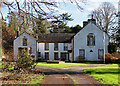
New Ellon Castle
This is the 'new' Ellon Castle, just along the terrace east of the 'old' Ellon Castle. It dates from teh early 18th century, but was altered in the late 18th century and again in the mid-19th century. It is a Category B Listed building. See https://portal.historicenvironment.scot/designation/LB31109 for a full description and https://en.wikipedia.org/wiki/Ellon_Castle for a potted history and https://www.elloncastlegardens.net/history/ .
Image: © Anne Burgess
Taken: 18 Feb 2024
0.23 miles
3
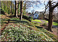
Snowdrops at Ellon Castle
The original castle stands on a terrace above the formal garden, and above the terrace is a wooded slope with profuse drifts of Snowdrops.
Image: © Anne Burgess
Taken: 18 Feb 2024
0.24 miles