IMAGES TAKEN NEAR TO
St. Marys Drive, ELLON, AB41 9LW
Introduction
This page details the photographs taken nearby to St. Marys Drive, AB41 9LW by members of the Geograph project.
The Geograph project started in 2005 with the aim of publishing, organising and preserving representative images for every square kilometre of Great Britain, Ireland and the Isle of Man.

There are currently over 7.5m images from over14,400 individuals and you can help contribute to the project by visiting https://www.geograph.org.uk
Image Map
Images are licensed for reuse under creativecommons.org/licenses/by-sa/2.0
Notes
- Clicking on the map will re-center to the selected point.
- The higher the marker number, the further away the image location is from the centre of the postcode.
Image Listing (21 Images Found)
Images are licensed for reuse under creativecommons.org/licenses/by-sa/2.0
Image
Details
Distance
1
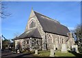
St Mary on the Rock Scottish Episcopal church, Ellon
The church is A-listed (LB31111: http://portal.historicenvironment.scot/designation/LB31111 ) largely for its interior.
Image: © Bill Harrison
Taken: 1 Mar 2020
0.11 miles
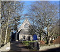
2
Saint Mary-on-the-Rock Episcopal Church
Saint Mary's Church in Ellon, viewed from the south-west.
Image: © Scott Cormie
Taken: 18 Jul 2023
0.11 miles
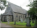
3
Ellon Scottish Episcopal Church
Dating from ca. 1870 in Decorated(?) revival style, dedicated to St Mary on the Rock and A-listed (LB31111: http://portal.historicenvironment.scot/designation/LB31111 ).
Image: © Bill Harrison
Taken: 1 Mar 2020
0.11 miles
4
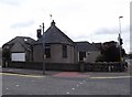
Former Tollhouse by the B9005, South Road, Ellon
Ellon by the A920 junction with the B9005, in parish of ELLON (Aberdeen District), The Toll House, South Road.
Surveyed
Milestone Society National ID: AD.ELL
Image: © Milestone Society
Taken: Unknown
0.13 miles
5
A Block of New Flats
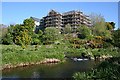
These flats on the south bank of the river are going to have a fine view over the River Ythan and the town of Ellon. My thanks to Andrew Wood who reminds me that this block replaces the short-lived Mercury Motor Inn, built in the 1970s on the site of the old coaching inn at Craighall.
Image: © Anne Burgess
Taken: 11 May 2009
0.17 miles
6
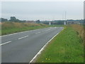
Entering Ellon
Link to local web site - http://www.visitellon.co.uk/index2.html
Image: © Ken Fitlike
Taken: 21 Aug 2007
0.18 miles
7
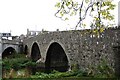
Old Bridge Ellon
Ellon's old bridge across the Ythan.
Image: © Andrew Wood
Taken: 12 Oct 2008
0.21 miles
8
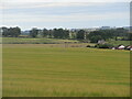
Hillhead of Fechil Trig Pillar
The triangulation pillar just visible in the middle of a field of barley at Hillhead of Fechil.
Image: © Scott Cormie
Taken: 18 Jul 2023
0.21 miles
9
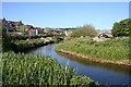
River Ythan
At the right there is a glimpse of an arch of the old bridge through an arch of the new bridge. The building at extreme left is a Somerfield supermarket which from this angle is sympathetically designed to fit into the townscape.
Image: © Anne Burgess
Taken: 11 May 2009
0.22 miles
10
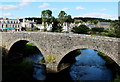
The Auld Brig, Ellon
Dating from 1793 and A-listed: http://www.britishlistedbuildings.co.uk/sc-31110-old-bridge-of-ellon- . It was replaced by the adjacent bridge around 1940.
Image: © Bill Harrison
Taken: 22 Sep 2013
0.22 miles