IMAGES TAKEN NEAR TO
Craigpark Circle, ELLON, AB41 9FF
Introduction
This page details the photographs taken nearby to Craigpark Circle, AB41 9FF by members of the Geograph project.
The Geograph project started in 2005 with the aim of publishing, organising and preserving representative images for every square kilometre of Great Britain, Ireland and the Isle of Man.

There are currently over 7.5m images from over14,400 individuals and you can help contribute to the project by visiting https://www.geograph.org.uk
Image Map
Images are licensed for reuse under creativecommons.org/licenses/by-sa/2.0
Notes
- Clicking on the map will re-center to the selected point.
- The higher the marker number, the further away the image location is from the centre of the postcode.
Image Listing (2 Images Found)
Images are licensed for reuse under creativecommons.org/licenses/by-sa/2.0
Image
Details
Distance
1
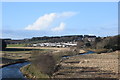
River Ythan looking upstream...
...as viewed from the Formartine and Buchan Way.
Image: © Bill Harrison
Taken: 23 Feb 2020
0.12 miles
2
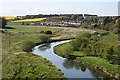
River Ythan
Looking upstream from the former railway viaduct towards a large housing estate on the western outskirts of Ellon.
Image: © Anne Burgess
Taken: 11 May 2009
0.18 miles