IMAGES TAKEN NEAR TO
Station Brae, ELLON, AB41 9DY
Introduction
This page details the photographs taken nearby to Station Brae, AB41 9DY by members of the Geograph project.
The Geograph project started in 2005 with the aim of publishing, organising and preserving representative images for every square kilometre of Great Britain, Ireland and the Isle of Man.

There are currently over 7.5m images from over14,400 individuals and you can help contribute to the project by visiting https://www.geograph.org.uk
Image Map
Images are licensed for reuse under creativecommons.org/licenses/by-sa/2.0
Notes
- Clicking on the map will re-center to the selected point.
- The higher the marker number, the further away the image location is from the centre of the postcode.
Image Listing (22 Images Found)
Images are licensed for reuse under creativecommons.org/licenses/by-sa/2.0
Image
Details
Distance
1
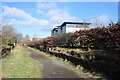
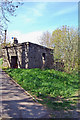
Site of Ellon station
Opened 1861, closed 1965 (the line was used for freight until ca. 1979), now part of the Formartine and Buchan Way.
Image: © Bill Harrison
Taken: 23 Feb 2020
0.01 miles
2
Ellon station (remains), 1997
View NE, towards Maud and Fraserburgh/Peterhead, also Boddam: ex-GNSR Aberdeen - Dyce - Fraserburgh/Peterhead line, junction of branch to Boddam. The station had closed to passengers 4/10/65 (goods 11/9/67), although freight to Fraserburgh continued until 6/10/79. The Boddam branch lost its passenger service 13/10/32 and closed completely 1/1/49.
Image: © Ben Brooksbank
Taken: 4 Jul 1997
0.02 miles
3
Ellon Station
The site of Ellon Station. This was a junction with a branch line running to Boddam. The railway to Fraserburgh and Peterhead is now a cycle path. It closed to passengers in 1965 and freight in 1979.
Image: © Richard Webb
Taken: 4 Aug 2011
0.02 miles
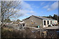
4
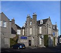
Station Hotel, Ellon
The trains stopped running 55 years ago (as of 2020) but the hotel survives. Note the classic McEwan's laughing cavalier advertising sign.
Image: © Bill Harrison
Taken: 1 Mar 2020
0.04 miles
5
Old Water Tank
Though the tank itself is long gone from the top, this granite base remains in situ at the northern end of the down platform at Ellon station. The station itself closed to passengers in 1965 as a result of the Beeching Cuts.
A selection of photos of the station when it was open can be found here: http://www.railbrit.co.uk/location.php?loc=Ellon
Image: © Alex Silver
Taken: 4 May 2011
0.06 miles
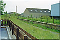
6
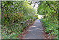
Ellon Station
The platform of the former Ellon Station still lines the path along the old railway line.
Image: © Anne Burgess
Taken: 3 Oct 2024
0.07 miles
8
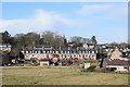
Foresters' Terrace, Ellon?
...with the Scottish Baronial edifice of Auchtercrag (now flats) just visible in the background. Thanks to Elaine for correcting the caption.
Image: © Bill Harrison
Taken: 23 Feb 2020
0.13 miles
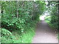
9
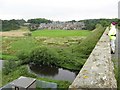
Ellon and Ythan
View from the cycle track on the Ellon viaduct over the river Ythan toward the outskirts of Ellon.
Image: © Mike and Kirsty Grundy
Taken: 25 Jul 2007
0.14 miles
10
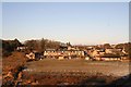
Forrester Terrace
A view of Forrester Terrace and Auchterellon from the old rail bridge over the Ythan.
Image: © Andrew Wood
Taken: 9 Jan 2011
0.14 miles