IMAGES TAKEN NEAR TO
Station Road, ELLON, AB41 9AY
Introduction
This page details the photographs taken nearby to Station Road, AB41 9AY by members of the Geograph project.
The Geograph project started in 2005 with the aim of publishing, organising and preserving representative images for every square kilometre of Great Britain, Ireland and the Isle of Man.

There are currently over 7.5m images from over14,400 individuals and you can help contribute to the project by visiting https://www.geograph.org.uk
Image Map
Images are licensed for reuse under creativecommons.org/licenses/by-sa/2.0
Notes
- Clicking on the map will re-center to the selected point.
- The higher the marker number, the further away the image location is from the centre of the postcode.
Image Listing (21 Images Found)
Images are licensed for reuse under creativecommons.org/licenses/by-sa/2.0
Image
Details
Distance
1
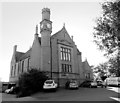
Victoria Hall, Ellon
Dating from 1901 and very heavily used by community groups in Ellon: http://www.victoriahallellon.co.uk/ .
Image: © Bill Harrison
Taken: 22 Sep 2013
0.05 miles
2
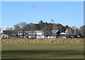
Ellon Primary School
School roll (2019-20): 287 + 60 in the nursery.
Image: © Bill Harrison
Taken: 1 Mar 2020
0.06 miles
4
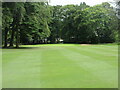
McDonald Golf Club, 17th Hole, The Doctor
The seventeenth hole at McDonald Golf Course in Ellon, looking to the green.
Image: © Scott Cormie
Taken: 28 Jul 2022
0.08 miles
5
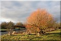
Tree by the Bridge
A riverbank tree by the Ythan with the Meklemill Footbridge in the background.
Image: © Andrew Wood
Taken: 30 Jan 2011
0.17 miles
7
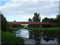
Footbridge over the Ythan
Footbridge over the river Ythan, Ellon
Image: © Derek Gray
Taken: 9 Jul 2008
0.21 miles
8
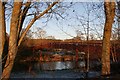
Meiklemill Footbridge
The footbridge linking Meiklemill to Modley in Ellon.
Image: © Andrew Wood
Taken: 9 Jan 2011
0.21 miles
9
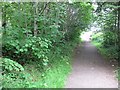
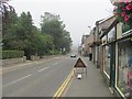
Ellon Station
The site of Ellon Station. This was a junction with a branch line running to Boddam. The railway to Fraserburgh and Peterhead is now a cycle path. It closed to passengers in 1965 and freight in 1979.
Image: © Richard Webb
Taken: 4 Aug 2011
0.21 miles
10
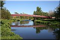
Ythan Footbridge
This bridge provides a short route for students to make their way to school from the south bank of the river, where there has been a huge expansion of the town in recent decades.
Image: © Anne Burgess
Taken: 11 May 2009
0.21 miles