IMAGES TAKEN NEAR TO
Arthrath, ELLON, AB41 8YT
Introduction
This page details the photographs taken nearby to AB41 8YT by members of the Geograph project.
The Geograph project started in 2005 with the aim of publishing, organising and preserving representative images for every square kilometre of Great Britain, Ireland and the Isle of Man.

There are currently over 7.5m images from over14,400 individuals and you can help contribute to the project by visiting https://www.geograph.org.uk
Image Map
Images are licensed for reuse under creativecommons.org/licenses/by-sa/2.0
Notes
- Clicking on the map will re-center to the selected point.
- The higher the marker number, the further away the image location is from the centre of the postcode.
Image Listing (4 Images Found)
Images are licensed for reuse under creativecommons.org/licenses/by-sa/2.0
Image
Details
Distance
2
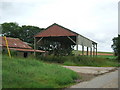
Whiteburn
Basic Dutch Barn - part of an unmodernised farmstead (no fancy new mega-sheds)
Plenty rusted corrugated iron for roofing
Image: © Ken Fitlike
Taken: 19 Jul 2007
0.02 miles
4
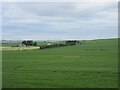
Field near Drakemyre
Looking north-west over a field with Drakemyre beyond.
Image: © Scott Cormie
Taken: 21 Jun 2024
0.25 miles