IMAGES TAKEN NEAR TO
Auchnagatt, ELLON, AB41 8YA
Introduction
This page details the photographs taken nearby to AB41 8YA by members of the Geograph project.
The Geograph project started in 2005 with the aim of publishing, organising and preserving representative images for every square kilometre of Great Britain, Ireland and the Isle of Man.

There are currently over 7.5m images from over14,400 individuals and you can help contribute to the project by visiting https://www.geograph.org.uk
Image Map
Images are licensed for reuse under creativecommons.org/licenses/by-sa/2.0
Notes
- Clicking on the map will re-center to the selected point.
- The higher the marker number, the further away the image location is from the centre of the postcode.
Image Listing (7 Images Found)
Images are licensed for reuse under creativecommons.org/licenses/by-sa/2.0
Image
Details
Distance
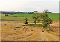
1
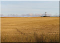
Stubble Field
Ready for ploughing at Mains of Inkhorn.
Image: © Anne Burgess
Taken: 3 Oct 2024
0.13 miles
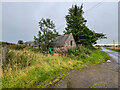
2
Howe of Catto Track
A track leading by the side of fields by the Howe of Catto, apparently leading towards a cottage by Catcraig.
Image: © Andrew Wood
Taken: 6 Sep 2020
0.17 miles
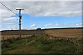
3
Phone mast at Inkhorn
....with pile of fertiliser in mid shot awaiting distribution before the next ploughing....
Image: © Ken Fitlike
Taken: 21 Jun 2007
0.19 miles
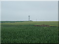
4
Inkhorn Mast
A telecommunication mast in a grain field by North Mains of Inkhorn.
Image: © Andrew Wood
Taken: 6 Sep 2020
0.20 miles
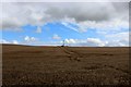
5
Clump of Trees
I thought this scrppy clump of trees must surely mark the site of a long-vanished farm, but even the oldest Ordnance Survey map shows nothing here.
Image: © Anne Burgess
Taken: 3 Oct 2024
0.21 miles
7
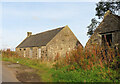
The Smithy
There are several derelict buildings at the road junction here.
Image: © Anne Burgess
Taken: 3 Oct 2024
0.22 miles