IMAGES TAKEN NEAR TO
Auchnagatt, ELLON, AB41 8XY
Introduction
This page details the photographs taken nearby to AB41 8XY by members of the Geograph project.
The Geograph project started in 2005 with the aim of publishing, organising and preserving representative images for every square kilometre of Great Britain, Ireland and the Isle of Man.

There are currently over 7.5m images from over14,400 individuals and you can help contribute to the project by visiting https://www.geograph.org.uk
Image Map
Images are licensed for reuse under creativecommons.org/licenses/by-sa/2.0
Notes
- Clicking on the map will re-center to the selected point.
- The higher the marker number, the further away the image location is from the centre of the postcode.
Image Listing (11 Images Found)
Images are licensed for reuse under creativecommons.org/licenses/by-sa/2.0
Image
Details
Distance
1
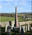
War memorial, Savoch of Deer kirkyard
It has a Canmore listing (339874: https://canmore.org.uk/site/339874/new-deer-auchnagatt-savoch-church-war-memorial ) but no details are given.
Image: © Bill Harrison
Taken: 29 Feb 2020
0.08 miles
2
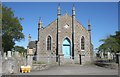
Savoch Kirk
This kirk, now disused, was built in 1834. The architect was possibly John Smith.
Image: © Anne Burgess
Taken: 14 May 2009
0.09 miles
3
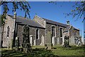
Savoch of Deer Kirk
The south elevation of the disused kirk, which was built in 1834. The kirkyard is still in use.
Image: © Anne Burgess
Taken: 14 May 2009
0.09 miles
4
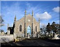
Former Savoch of Deer parish kirk
Dating from ca. 1834 and C-listed (LB16151): http://portal.historicenvironment.scot/designation/LB16151 . It looks like the door has been padlocked for a long time... 'Savoch' is said to mean 'a pleasant place' according to 'Celtic Place-names in Aberdeenshire' by John Milne (publ. 1912), available as a free e-book or download from archive.org
Image: © Bill Harrison
Taken: 29 Feb 2020
0.09 miles
5
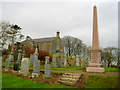
War memorial and disused country kirk, near to Auchnagatt
Magnificent memorial, in the form of an obelisk made from pink peterhead granite, sitting in a remote country kirkyard.
Image: © Martyn Gorman
Taken: 15 Feb 2007
0.13 miles
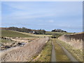
6
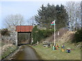
Play area...
...beside the Formartine and Buchan Way with (why not...) a Welsh flag. The bridge carries the minor road to Savoch kirk.
Image: © Bill Harrison
Taken: 29 Feb 2020
0.16 miles
7
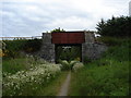
Bridge over the F & B Way
Bridge over the Formartine & Buchan Way
Image: © Derek Gray
Taken: 16 Jun 2008
0.16 miles
8
Ebrie Lodge
View of Ebrie Lodge from the F & B Way
Image: © Derek Gray
Taken: 23 Jul 2008
0.18 miles
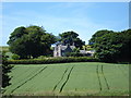
9
Rural manse and kirk...
..as seen from the Formartine and Buchan Way. The former manse is centre left and on the hill in the distance partly hidden by trees is the remote Savoch of Deer kirk (erected ca. 1833) with the former church school just discernible to its left. Ebrie Burn is in the foreground. According to Celtic Placenames in Aberdeenshire by John Milne, 'ebrie' means muddy.
Image: © Bill Harrison
Taken: 29 Feb 2020
0.19 miles
10
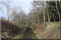
Signs of spring...
...on the Formartine and Buchan Way south of Mill of Elrick.
Image: © Bill Harrison
Taken: 29 Feb 2020
0.19 miles