IMAGES TAKEN NEAR TO
Auchnagatt, ELLON, AB41 8UL
Introduction
This page details the photographs taken nearby to AB41 8UL by members of the Geograph project.
The Geograph project started in 2005 with the aim of publishing, organising and preserving representative images for every square kilometre of Great Britain, Ireland and the Isle of Man.

There are currently over 7.5m images from over14,400 individuals and you can help contribute to the project by visiting https://www.geograph.org.uk
Image Map
Images are licensed for reuse under creativecommons.org/licenses/by-sa/2.0
Notes
- Clicking on the map will re-center to the selected point.
- The higher the marker number, the further away the image location is from the centre of the postcode.
Image Listing (3 Images Found)
Images are licensed for reuse under creativecommons.org/licenses/by-sa/2.0
Image
Details
Distance
1
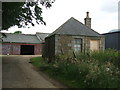
Slamptonhill Farm
Note - alert collie farm dog poised to repel Geographers.
Building in the foreground is a bothy - very basic accommodation for young single farm workers in more labour intensive times.
Image: © Ken Fitlike
Taken: 19 Jul 2007
0.04 miles
2
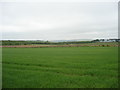
View of Annochie Moss
Annochie Moss from Slamptonhill
Image: © Derek Gray
Taken: 1 Jun 2008
0.05 miles