IMAGES TAKEN NEAR TO
Auchnagatt, ELLON, AB41 8UA
Introduction
This page details the photographs taken nearby to AB41 8UA by members of the Geograph project.
The Geograph project started in 2005 with the aim of publishing, organising and preserving representative images for every square kilometre of Great Britain, Ireland and the Isle of Man.

There are currently over 7.5m images from over14,400 individuals and you can help contribute to the project by visiting https://www.geograph.org.uk
Image Map
Images are licensed for reuse under creativecommons.org/licenses/by-sa/2.0
Notes
- Clicking on the map will re-center to the selected point.
- The higher the marker number, the further away the image location is from the centre of the postcode.
Image Listing (15 Images Found)
Images are licensed for reuse under creativecommons.org/licenses/by-sa/2.0
Image
Details
Distance
1
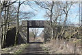
Road bridge...
...over the Formartine and Buchan Way.
Image: © Bill Harrison
Taken: 8 Mar 2020
0.04 miles
2
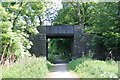
Cairncummer Bridge
A road ridge crossing the old Buchan Line. It leads to South Kiddshill as well as nearby Cairncummer.
Image: © Andrew Wood
Taken: 9 Jun 2018
0.05 miles
4
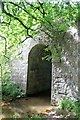
Ebrie Span
The Ebrie Burn flowing under its own span of the flyover it shares with a rail bridge by Cairncummer.
Image: © Andrew Wood
Taken: 9 Jun 2018
0.05 miles
5
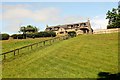
Cairncummer Steading
A converted farmstead by the Buchan Line walk.
Image: © Andrew Wood
Taken: 9 Jun 2018
0.08 miles
6
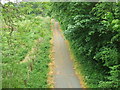
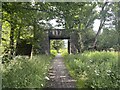
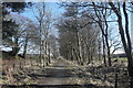
Formartine and Buchan Walkway
Going south-west towards Auchnagatt,
Image: © Ken Fitlike
Taken: 8 Jun 2007
0.10 miles
8
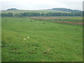
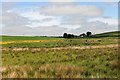
Field at South Greenbrae
looking towards Whin Hill - a couple of grid squares to the west
Image: © Ken Fitlike
Taken: 8 Jun 2007
0.15 miles
9
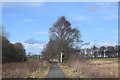
Straight on to Auchnagatt?
...on the Formartine and Buchan Way. The attractive trees have grown in the last 40 years after the tracks were lifted ca. 1979.
Image: © Bill Harrison
Taken: 8 Mar 2020
0.15 miles
10
Greenbrae Wetland
Wet fields by South Greenbrae with South Kiddshill in the distance.
Image: © Andrew Wood
Taken: 9 Jun 2018
0.18 miles