IMAGES TAKEN NEAR TO
Auchnagatt, ELLON, AB41 8TX
Introduction
This page details the photographs taken nearby to AB41 8TX by members of the Geograph project.
The Geograph project started in 2005 with the aim of publishing, organising and preserving representative images for every square kilometre of Great Britain, Ireland and the Isle of Man.

There are currently over 7.5m images from over14,400 individuals and you can help contribute to the project by visiting https://www.geograph.org.uk
Image Map
Images are licensed for reuse under creativecommons.org/licenses/by-sa/2.0
Notes
- Clicking on the map will re-center to the selected point.
- The higher the marker number, the further away the image location is from the centre of the postcode.
Image Listing (14 Images Found)
Images are licensed for reuse under creativecommons.org/licenses/by-sa/2.0
Image
Details
Distance
1
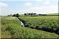
The Ebrie to Crowniehillock
The Ebrie Burn flowing in the direction of Crowniehillock Farm.
Image: © Andrew Wood
Taken: 9 Jun 2018
0.04 miles
2
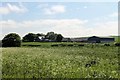
Crowniehillock Farm
A farm on the outskirts of Auchnagatt from the old Buchan Line walkway.
Image: © Andrew Wood
Taken: 9 Jun 2018
0.04 miles
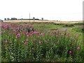
3
Open countryside just north of Auchnagatt?
...on the Formartine and Buchan Way.
Image: © Bill Harrison
Taken: 8 Mar 2020
0.09 miles
4
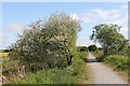
Path by Willow
The Buchan Line walkway to Augnagatt and a willow tree growing in the verge.
Image: © Andrew Wood
Taken: 9 Jun 2018
0.11 miles
5
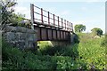
Ebrie Bridge
Another old rail bridge by the Ebrie Burn.
Image: © Andrew Wood
Taken: 9 Jun 2018
0.13 miles
6
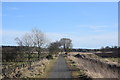
North of Auchnagatt
View from the trackbed of the Formartine and Buchan Railway, now a cycle/footpath from Dyce to Fraserburgh with a branch to Peterhead.
Image: © Richard Webb
Taken: 4 Aug 2011
0.20 miles
7
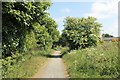
Path to Auchnagatt
The last stretch of pathway following the old rail line from Maud to Auchnagatt.
Image: © Andrew Wood
Taken: 9 Jun 2018
0.21 miles
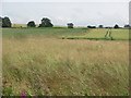
8
Looking up to Catcraig from the Formartine and Buchan Way
The foreground is either the site of Auchnagatt Station or near it. The platforms were further south and 1950's mapping show buildings here.
Image: © Richard Webb
Taken: 4 Aug 2011
0.21 miles
9
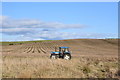
Abandoned tractor...
...which hasn't moved for some time... (https://www.geograph.org.uk/photo/5810399 ).
Image: © Bill Harrison
Taken: 8 Mar 2020
0.22 miles
10
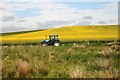
Abandoned Tractor
A tractor left in front of a field of rape seed in bloom.
Image: © Andrew Wood
Taken: 9 Jun 2018
0.23 miles