IMAGES TAKEN NEAR TO
Auchnagatt, ELLON, AB41 8TU
Introduction
This page details the photographs taken nearby to AB41 8TU by members of the Geograph project.
The Geograph project started in 2005 with the aim of publishing, organising and preserving representative images for every square kilometre of Great Britain, Ireland and the Isle of Man.

There are currently over 7.5m images from over14,400 individuals and you can help contribute to the project by visiting https://www.geograph.org.uk
Image Map
Images are licensed for reuse under creativecommons.org/licenses/by-sa/2.0
Notes
- Clicking on the map will re-center to the selected point.
- The higher the marker number, the further away the image location is from the centre of the postcode.
Image Listing (3 Images Found)
Images are licensed for reuse under creativecommons.org/licenses/by-sa/2.0
Image
Details
Distance
2
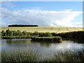
Pond at Backmoss
Pond at Backmoss. People only come here to shoot the ducks. Hill of Cauldhame is in the background
Image: © Derek Gray
Taken: 23 Jun 2008
0.21 miles
3
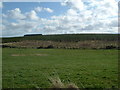
View north east at Little Tack
Shantler Hill on the horizon
Image: © Les Harvey
Taken: 19 Apr 2008
0.24 miles