IMAGES TAKEN NEAR TO
Collieston, ELLON, AB41 8SR
Introduction
This page details the photographs taken nearby to AB41 8SR by members of the Geograph project.
The Geograph project started in 2005 with the aim of publishing, organising and preserving representative images for every square kilometre of Great Britain, Ireland and the Isle of Man.

There are currently over 7.5m images from over14,400 individuals and you can help contribute to the project by visiting https://www.geograph.org.uk
Image Map
Images are licensed for reuse under creativecommons.org/licenses/by-sa/2.0
Notes
- Clicking on the map will re-center to the selected point.
- The higher the marker number, the further away the image location is from the centre of the postcode.
Image Listing (5 Images Found)
Images are licensed for reuse under creativecommons.org/licenses/by-sa/2.0
Image
Details
Distance
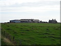
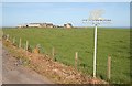
1
Distant view of Clochtow Farm
Clochtow means 'stone in a howe' (howe = tumulus or barrow) according to Celtic Placenames in Aberdeenshire by Milne although there are no obvious nearby tumuli.
Image: © Bill Harrison
Taken: 24 Jul 2020
0.01 miles
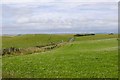
2
The farm of Clochtow
Part of Slains Estate Clochtow farm lies North of the fishing village of Collieston in an area of fertile land overlooking the North Sea
Image: © Martyn Gorman
Taken: 1 Mar 2008
0.01 miles
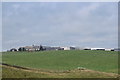
3
Clochtow
There's no need to guess what Clochtow specialises in. However there were also sheep in evidence.
Image: © Anne Burgess
Taken: 2 Jul 2010
0.02 miles