IMAGES TAKEN NEAR TO
Collieston, ELLON, AB41 8SQ
Introduction
This page details the photographs taken nearby to AB41 8SQ by members of the Geograph project.
The Geograph project started in 2005 with the aim of publishing, organising and preserving representative images for every square kilometre of Great Britain, Ireland and the Isle of Man.

There are currently over 7.5m images from over14,400 individuals and you can help contribute to the project by visiting https://www.geograph.org.uk
Image Map
Images are licensed for reuse under creativecommons.org/licenses/by-sa/2.0
Notes
- Clicking on the map will re-center to the selected point.
- The higher the marker number, the further away the image location is from the centre of the postcode.
Image Listing (3 Images Found)
Images are licensed for reuse under creativecommons.org/licenses/by-sa/2.0
Image
Details
Distance
1
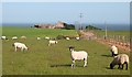
North Newclochtow
Recently shorn sheep by the access road to North Newclochtow.
Image: © Anne Burgess
Taken: 2 Jul 2010
0.02 miles
3
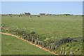
Field Boundaries
A variety of fences, gates and a burn separate the fields here. The farm on the skyline is Ogston, in the next square.
Image: © Anne Burgess
Taken: 2 Jul 2010
0.25 miles